Last year I posted the rain and temperature data for 2017, our first full year here in the northwest. That data can be found here.
The 2018 data is listed below. Overall, we had less rain in 2018 than in 2017 and it was slightly warmer in 2018. The average rainfall for Hansville is 33″ per year. For more detail on the rain shadow effect in the area, refer to last year’s post.
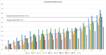
2018 Weather Data
| Month | Avg High | Avg Low | Total Precipitation |
|---|---|---|---|
| Jan | 47.3 | 41.2 | 4.65 |
| Feb | 46.1 | 36.6 | 3.28 |
| Mar | 53.8 | 37.3 | 1.49 |
| Apr | 58.6 | 42.9 | 4.63 |
| May | 69.9 | 47.9 | 0.45 |
| Jun | 68.9 | 50.5 | 2.51 |
| Jul | 77.4 | 53 | 0.11 |
| Aug | 74.5 | 53.5 | 0.32 |
| Sep | 69.2 | 50.8 | 1.72 |
| Oct | 59.0 | 46.1 | 2.98 |
| Nov | 51.0 | 43.0 | 3.72 |
| Dec | 46.3 | 38.7 | 4.45 |
Total precipitation recorded at the weather station for 2018 was 30.31 inches. This is low due to the station going off-line a few times during the year and not recording. However, it is in the ballpark and it looks as though we were slightly under the yearly average for 2018.
Some other stats that I pulled from the 2018 data include:
- Hottest Day: 88.5º on Jun 18th
- Coldest Day: 25.2º on Feb 23rd
- Highest Wind Gust: 23 mph on Jan 29th, Feb 25th, Apr 7th, and Nov 3rd
- Lowest Barometric Pressure: 29.34 on Apr 7th
- Highest Barometric Pressure: 30.57 on Nov 8th
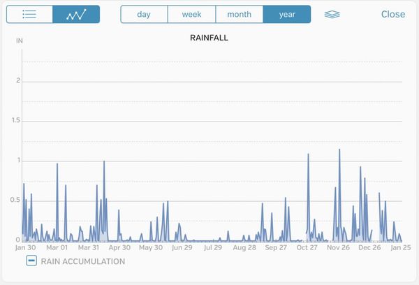
- Most Precipitation in a Day: 1.15″ Nov 26th


